Lampung Geh, Bandar Lampung — As December 1, 2025 approaches, atmospheric dynamics across the Lampung region have reactivated following the dissipation of Tropical Cyclone Senyar. A confluence of key climate indices now indicates conditions are highly favorable for a significant increase in rain cloud formation.
Data compiled by Lampung Geh, sourced from lampung.bmg.go.id, highlights several critical factors. A positive SOI value of +14.3, a weakly negative ENSO at -0.95, and a negative DMI of -0.6 collectively amplify the convective potential across western Indonesia, a region that prominently includes Lampung. Furthermore, active Kelvin waves detected over southern Sumatra are also significantly contributing to the development of these convective clouds in the area.
While the Madden-Julian Oscillation (MJO) is currently in phase 7 and its influence is not particularly significant, localized atmospheric conditions play a crucial role. Factors such as wind shear, convergence zones, and anomalies in sea surface temperatures continue to provide an ample supply of water vapor, essential for the ongoing formation of rain clouds. High humidity levels, increasing CAPE (Convective Available Potential Energy) values, and a re-destabilized atmosphere are collectively intensifying the potential for significant rainfall across the Lampung province.
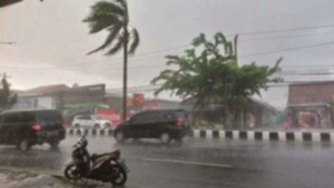
Looking ahead to the coming week, Lampung’s weather is generally expected to be partly cloudy to cloudy. However, there is a pronounced potential for moderate to heavy rain, frequently accompanied by lightning, particularly during the afternoon, evening, and night hours.
BMKG reports that the potential for widespread rain is noted almost daily, with the most frequently affected areas including Pesisir Barat, Tanggamus, Way Kanan, Mesuji, Tulang Bawang, Tulang Bawang Barat, Lampung Utara, Lampung Selatan, as well as most other districts and cities within the province.
Residents are strongly urged to remain vigilant against the potential for lightning strikes, strong winds, and localized flooding, especially during peak rainfall hours. (Dho/Ansa)
Summary
The Lampung region is forecasted to experience moderate to heavy rain, often accompanied by lightning, from December 1-7, 2025, according to BMKG. This increase in rainfall potential follows the dissipation of Tropical Cyclone Senyar and is attributed to reactivated atmospheric dynamics. Contributing factors include a positive SOI, weakly negative ENSO, and negative DMI amplifying convective potential in western Indonesia, along with active Kelvin waves and localized conditions providing ample water vapor.
Rain is anticipated almost daily, particularly during afternoon, evening, and night hours, affecting most districts and cities within the province, including Pesisir Barat, Tanggamus, and Lampung Utara. While generally partly cloudy to cloudy, residents are strongly advised to remain vigilant. This vigilance is crucial against potential risks such as lightning strikes, strong winds, and localized flooding during periods of peak rainfall.