
Minister of Environment, Hanif Faisol Nurofiq, has asserted that recent environmental disasters plaguing Sumatra and Aceh are not solely attributable to climate or weather factors. He emphasized that a critical underlying issue is the unpreparedness of landscapes and spatial planning to effectively withstand extreme rainfall events. This crucial perspective was shared during the presentation of the COP30 UNFCCC Brazil results at Hotel Kempinski Indonesia, Jakarta, on Tuesday (2/12).
Hanif elaborated on this point, stating, “In this context, we are not simply blaming the climate. There are serious problems within the landscape itself that need to be addressed and rectified.” He underscored the paramount importance of robust ecosystem readiness and integrated spatial planning in mitigating the impacts of increasing extreme weather occurrences. He reiterated, “I am merely explaining that I am not blaming the climate, but rather our own unpreparedness to cope. That is what led to these disasters.”
To illustrate his argument, Hanif provided a series of striking examples of extreme weather incidents across various regions, extending beyond Sumatra to include Jakarta and Bali. He cited the Ciliwung River floods in Jakarta, which occurred in February and August, causing casualties despite a relatively moderate rainfall of just 147 millimeters over two days. The river’s funnel-like morphology combined with dense population settlements significantly amplified the risk of fatalities.
Highlighting another vulnerable area, Hanif drew attention to the Ayung River watershed in Bali, where forest cover has alarmingly dwindled to only about 3 percent. He reported that rainfall reaching 245 millimeters in this area led to a tragic outcome, with 21 people losing their lives and one person still missing. These cases underscore the direct link between inadequate environmental management and heightened disaster vulnerability.
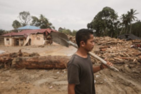
Furthermore, Hanif presented data on extreme rainfall in Sumatra, frequently triggered by tropical cyclones. In Batang Toru, for instance, rainfall reached approximately 300 millimeters within two days. Despite not being as high as other areas like Aceh, the impact was profound due to the landscape’s distinct V-shape. The compromised integrity of the slopes on both sides rendered regions in North, Central, and South Tapanuli exceptionally susceptible to disaster.

Continuing with examples from Sumatra, Hanif detailed the exceptionally severe rainfall in Sibolga, North Sumatra, which saw nearly 400 millimeters of precipitation. This intense downpour instigated massive landslides that tragically buried residents. Aceh also recorded a staggering 400 millimeters of rainfall, resulting in an immense volume of water—estimated at 9.7 billion cubic meters—in just two days. Hanif questioned the ability of anyone to survive such an overwhelming inundation. He also highlighted the extreme conditions in West Sumatra, where a steep and short landscape exacerbated the impact, leading to a significant number of casualties.
The Minister acknowledged that drastic shifts in spatial planning have occurred in several areas, notably Batang Toru. In this particular region, the upstream sections of the watershed are designated as “Other Use Areas” (APL) rather than protected forest zones. This classification has led to minimal tree cover in critical areas that should naturally serve as primary buffers against erosion and flooding. Hanif explained, “When it rains there, it’s guaranteed there are no trees. While there is 38 percent tree cover, it’s concentrated in the middle and downstream areas. If it were at the peak, the outcome might have been different.”

In response to these critical issues, the government is currently gathering detailed data, including satellite imagery, and has invited all relevant entities along the Batang Toru watershed for a thorough investigation. Hanif assured the public that the government is committed to shedding light on these incidents and holding accountable the parties responsible for aggravating the environmental damage. He affirmed, “We will bring this case to light so that the numerous victims do not go without justice. This involves aggravated environmental damage, and we will certainly implement future improvements.”
Hanif also confirmed that the BMKG (Meteorological, Climatological, and Geophysical Agency) had indeed provided local governments with information regarding the impending tropical cyclones. However, he noted that the exact strength of such phenomena remains inherently difficult to predict. He concluded by emphasizing that these events must serve as a crucial lesson, underscoring the absolute necessity of robust and proactive adaptation plans to safeguard communities and ecosystems against future extreme weather challenges.
Summary
Environment Minister Hanif Faisol Nurofiq asserted that recent environmental disasters in Sumatra and Aceh are not solely attributable to climate change. He emphasized that the primary issue is the unpreparedness of landscapes and inadequate spatial planning to effectively cope with extreme rainfall events. The minister highlighted the critical need for robust ecosystem readiness and integrated spatial planning to mitigate disaster impacts.
Hanif provided examples such as the Ciliwung River floods in Jakarta and the Ayung River in Bali, where factors like dense settlements, river morphology, and diminished forest cover amplified casualties. He also detailed Sumatra’s extreme rainfall impacts, pointing out that altered spatial planning in areas like Batang Toru, where upstream sections are “Other Use Areas” instead of protected forests, led to insufficient tree cover. The government is now investigating these incidents, gathering data, and committed to ensuring accountability for aggravated environmental damage, underscoring the vital need for proactive adaptation plans.